


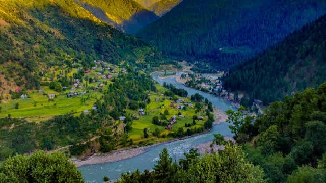
KERAN VELLEY
Keran Valley is one of the most beautiful and lesser-explored destinations in North Kashmir, situated in Kupwara district along the banks of the Kishanganga River. Surrounded by lush green mountains, dense forests, traditional villages and peaceful Himalayan landscapes, Keran offers a completely different experience from the popular tourist destinations of Gulmarg, Pahalgam and Sonamarg. Its location near the Line of Control also gives the valley a unique border-tourism character.
About the Destination
Keran Valley is a spectacular offbeat destination in Kupwara district of Jammu & Kashmir, located in the northern part of the Kashmir Valley. The valley lies along the Kishanganga River, which forms part of the natural boundary in this region. Its combination of snow-covered mountains, dense forests, green meadows, flowing streams and traditional Kashmiri villages makes it one of the most fascinating destinations for travellers looking to explore the quieter side of Kashmir.
Unlike destinations such as Gulmarg and Pahalgam, Keran remains relatively peaceful and less commercialized. The journey itself is an important part of the experience. As travellers move deeper into North Kashmir, the landscape gradually changes from populated areas and agricultural fields to forest-covered mountains, narrow valleys and dramatic Himalayan scenery.
One of the most notable points on the route is Pharkyan/Farkyan Pass, which has to be crossed to reach the Keran Valley. The Government of Jammu & Kashmir's Kupwara district website specifically notes that reaching Keran involves crossing the approximately 8,000-foot-high Farkyan Pass.
After crossing the mountain pass, the road descends towards the valley, where the Kishanganga River and surrounding mountains create a spectacular landscape. The valley is characterized by small settlements, green agricultural fields, traditional houses and forested slopes.
Keran is also significant for border tourism. Because of its location close to the Line of Control, visitors can experience a landscape where geography, history and local culture come together. The Ministry of Tourism's Utsav portal describes Keran as being on the Kishanganga River near the LoC and highlights its dense forests, green fields and scenic mountain surroundings.
What Makes Keran Valley Special?
🌲 Untouched Natural Beauty
Keran is surrounded by forests, mountains, meadows and streams, making it ideal for nature lovers and photographers.
🏔️ Himalayan Landscapes
The drive towards Keran provides impressive views of the surrounding mountain ranges and valleys.
🏞️ Kishanganga River
The river is one of the defining features of the valley and adds to its scenic character.
🏡 Traditional Village Life
Visitors can experience a quieter and more traditional side of Kashmir, including village landscapes, local agriculture and traditional architecture.
🇮🇳 Border Tourism
Keran's location close to the LoC makes it a distinctive destination within Kashmir's growing border-tourism circuit. Keran, Machil, Karnah and other North Kashmir destinations are currently being promoted as part of the region's tourism potential.
📸 Photography
The mountains, river, forests, traditional houses and changing landscapes provide excellent opportunities for landscape and travel photography.
---
How to Reach
How to Reach Keran Valley
From Srinagar
The commonly used road route is:
Srinagar → Sopore/Handwara → Kupwara → Kralpora/Mandian → Pharkyan Pass → Keran
Depending on the exact route and road conditions, Keran is roughly 130–140 km from Srinagar, and the journey can take around 4–6 hours. Travel time varies because of mountain roads, checkpoints, traffic and weather.
From Kupwara
Kupwara is the main gateway for Keran.
The road continues from Kupwara towards the Keran sector, passing through mountain terrain and the Pharkyan/Farkyan area before descending towards the valley. The official district website confirms that the route to Keran involves crossing Farkyan Pass.
By Air
The nearest major airport is Sheikh ul-Alam International Airport, Srinagar. From Srinagar, visitors continue by road towards Kupwara and then Keran.
By Train
Travellers arriving by train can reach the Kashmir railway network and then continue towards Kupwara by road. Because Keran itself has no railway connection, the final part of the journey must be completed by road.
---
Altitude
There is some variation in published figures because different sources refer to different points within the Keran area.
For the Keran village itself, geographic mapping data gives an elevation of approximately 1,544 metres (5,066 feet) above sea level.
Another mapped Keran locality is listed at approximately 1,673 metres (5,489 feet).
For website/SEO purposes, I recommend writing:
Altitude: Approximately 1,500–1,700 metres (4,900–5,600 feet) above sea level
This is more accurate than giving one exact number for the entire valley.
> Important: Do not confuse Keran Valley's elevation with Pharkyan Pass, which is substantially higher. The official Kupwara website gives Farkyan Pass at approximately 8,000 feet.